
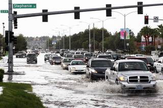
Drivers pass through street flooding near Sunset and Stephanie roads after heavy rains came through the area Tuesday, Oct. 4, 2011.
Wednesday, Oct. 5, 2011 | 6:34 a.m.
Sun Coverage
Sun weather coverage
Pack your umbrella again and put on some long sleeves. Cooler temperatures, strong winds, rain in the valleys and snow in the mountains are blustering into the Las Vegas region.
While Las Vegas has been getting wet this week — another .03 of an inch was the official amount from Tuesday — a stronger and colder storm will move down from the northwest today and linger across the region through Thursday, according to the National Weather Service.
Temperatures today in the valley will range from highs around 68 degrees on the west side of the valley to around 76 degrees on the east side, the weather service said.
Strong wind gusts ahead of the low will hit much of the southern Great Basin and Mojave Desert, forecasters said. Winds will be from the southwest at 20 to 30 mph, with gusts up to 40 mph this afternoon. The weather service has issued a lake wind advisory for Lake Mead and Lake Mohave. Boaters are urged to use extreme caution because of high waves that could tip or swamp smaller crafts.
A wind advisory has also been issued from 9 a.m. through midnight today for the Spring Mountains and Red Rock Canyon, where winds could gust as high as 50 mph. Crosswinds could make driving difficult for motorists with high-profile vehicles, the weather service said.
The mountains will be getting a considerable amount of snow — for southern Nevada and northwest Arizona, the snow level will remain above elevations of 9,000 feet today, then fall to as low as 6,000 feet tonight, forecasters said. The snow level at Mount Charleston is expected to lower to 8,200 feet this afternoon. New snow accumulation of less than a half inch is possible tonight and again Thursday, forecasters said.
At 5:56 a.m. today, the temperature at McCarran International Airport was 61 degrees. The normal low for today's date is 63 degrees. The record low was 41 degrees, set in 1937. McCarran recorded .03 of an inch of rain on Tuesday.
Around the valley just before 6 a.m., temperatures were 61 degrees at North Las Vegas Airport, 62 degrees at Nellis Air Force Base and 60 degrees at Henderson Executive Airport.
Temperatures in the valley were to rise today to 66 degrees by 9 a.m., to 71 degrees by noon and reach a high of 74 degrees by 3 p.m., forecasters said. The normal high for today's date is 86 degrees and the record high was 99 degrees, set in 1980.
Temperatures are expected to drop to 72 degrees by 6 p.m., to 65 degrees by 9 p.m. and to 60 degrees by midnight, forecasters said.
Thursday's morning low will be 56 degrees and Thursday's high will climb to 67 degrees, they said.
Join the Discussion:
Check this out for a full explanation of our conversion to the LiveFyre commenting system and instructions on how to sign up for an account.
Full comments policy