
Power lines, such as those near Hoover Dam, cannot be built to reach remote areas for renewable energy development until the areas for energy production are agreed upon. Several entities have offered or are working on maps locating renewable energy resources.
Tuesday, June 16, 2009 | 2 a.m.
Related Document (.pdf)
Sun Archives
- State thinks big on solar power (6-15-2009)
- The power of the desert (4-5-2009)
- State faces obstacles to cashing in on sun (3-9-2009)
Sun Coverage
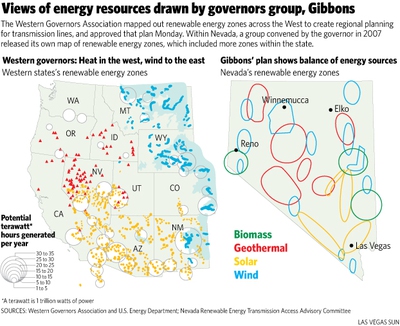
On one map they look like bubbles. On another they’re more like hot dogs.
These shaded circles and oblongs in Nevada and across the West could one day be clusters of solar power plants, wind farms or geothermal energy projects.
The growing number of maps drawn by groups hoping to guide the expected explosion in renewable energy show there is no firm agreement on where such projects will be concentrated.
The latest plan examining where renewable energy projects should be located was released Monday by the Western Governors’ Association, part of the yearlong first phase of its Western Renewable Energy Zones planning process.
In Nevada the plan shows circles for solar potential in the state’s middle and southern end, and indicates a concentration of geothermal energy — power generated from hot water below the Earth’s surface — in Northern Nevada. In all, about 50 zones dot 11 western U.S. states and parts of Canada and Mexico in the Western Governors’ Association plan. Each zone identified on the map has at least 1,500 megawatts of energy capacity.
“We were looking to see where the best resources are to facilitate sound planning and to guide major investments across the region,” said Tom Darin, an attorney for Western Resource Advocates, who worked on the study.
To spur renewable energy production, developers await the construction of transmission lines to reach into remote areas. A consensus on where to locate the projects is key to that effort, experts say.
Efforts to wire the West received a boost from the federal economic stimulus package, which includes $3.2 billion for transmission lines for renewable energy.
The Energy Department funded the Western Governors’ study.
The group, which includes all Western governors on its board, including Gov. Jim Gibbons, unveiled the study at its meeting in Park City, Utah. It also announced that the governors had signed a memorandum of understanding with the U.S. Interior Department to protect important wildlife corridors in the region. On hand were Interior Secretary Ken Salazar and Energy Secretary Steven Chu.
For those looking to develop renewable energy lines, yet another study could add to the visual cacophony of dots on a map — all attempting to identify future renewable energy “zones.”
In addition to the Western Governors’ map, Gibbons has his own Renewable Energy Zones and Transmission Interconnects Map, developed a year and a half ago by his Renewable Energy Transmission Access Advisory Committee. That map includes 12 wind zones throughout the state, in addition to four large solar zones, six geothermal zones and four zones for biomass energy production.
On the regional planning map from the governors association, wind is assigned only to the environs of Montana, Wyoming and eastern parts of Colorado and New Mexico, while solar zones are concentrated in Southern Nevada, Arizona and California.
California’s Renewable Energy Transmission Initiative has also released its own maps that show solar zones in Nevada.
More maps will follow.
Assembly Bill 387 requires NV Energy to provide the Public Utilities Commission with its own map of renewable energy zones in need of transmission lines.
Senate Bill 358, meanwhile, directs a newly created Renewable Energy Authority to develop its own map of renewable energy zones.
Both bills were approved by the Legislature and signed by the governor.
In addition to the state and regional planning, a bill pending in the U.S. Senate pushed by Nevada Sen. Harry Reid could transfer much of the control over transmission line planning and implementation to the federal government.
Charles Benjamin, who oversees Nevada activities for Western Resource Advocates, said he believes that instead of adding more confusion to the situation, the various planning processes will ultimately bring order to renewable energy development in the state.
“If you do get three different processes all identifying the same areas, that gives you confidence,” he said. “It’s like getting a second or a third opinion.”
Join the Discussion:
Check this out for a full explanation of our conversion to the LiveFyre commenting system and instructions on how to sign up for an account.
Full comments policy