
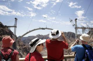
The Hoover Dam bypass bridge over the Colorado river seen from the Hoover Dam observation deck.
Saturday, Aug. 1, 2009 | 2:05 a.m.
Bridging The Gap
The Federal Highway Administration on July 31, 2009, updates the process and upcoming milestones of the Hoover Dam Bypass bridge project.
A computer rendering of the completed bridge against the Hoover Dam.
Hoover Dam bypass bridge
Related links
Sun coverage
A decade-long, multi-million-dollar project is about to reach a major milestone.
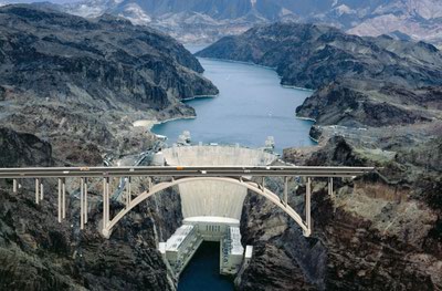
The two sides of the Hoover Dam bypass bridge’s twin arches will be connected in the coming weeks, creating the largest concrete arch in North America.
The $114-million bridge is about 85 percent complete, with just a six-foot gap in the center of the 1,060-foot arch.
The Federal Highway Administration held a media briefing on Friday to show off the bridge.
It is the centerpiece of the Hoover Dam bypass project, which is being built to carry traffic on U.S. 93 from Arizona to Nevada without crossing the Hoover Dam. The project should be finished by the end of next year.
A lot of intensive work, however, remains to be done on the arch and bridge, said Project Manager Dave Zanetell of the Federal Highway Administration.
Once the arch is connected, which should happen in the next two or three weeks, crews will work through September removing equipment and the temporary support towers and cable system that currently hold the arch in place.
Once the cables are removed, the arch will be self-supporting and free standing.
Once the arch is complete, 11 months of work will remain to complete the bridge, including building columns on the arches that will support the roadway.
The bridge will be 1,900 feet long and is located 1,700 feet downstream from the dam and 890 feet above the Colorado River.
While the bridge may be an engineering marvel — with about 1,200 construction workers and 300 engineers participating in the project at some point — it is just one part of the overall Hoover Dam bypass.
“The bypass is far more than just this bridge,” Zanetell said.
Building the approaches to the bridge was no small task, he said. About four miles of four-lane highway were built to carry traffic to and from the bridge. That may not sound like much, but the rugged terrain made the project more complicated than just paving a new road.
The approach in Arizona is just two miles but cost $21.5 million and included a 900-foot-long bridge, one of the largest of its kind in Arizona.
The approach in Nevada was an even larger project.
The two miles of roadway cost more than $30 million to build and included six new bridges just to get motorists to the main bridge over the river.
The total project is expected to cost $240 million, with $100 million coming from the federal government and $20 million each coming from Arizona and Nevada. The remaining $100 million is from bonds, half of which were advanced by each state.
The bypass is expected to save a significant amount of travel time.
The new road and bridge will cut travel in the area on U.S. 93 from 6.3 miles that take 16.5 minutes to travel to 5.5 miles, which at a speed of 55 mph will take just six minutes.
Actual travel time now across the dam — often congested with tourist traffic — can be more than 30 minutes.
Officials say traffic on the dam has decreased significantly since Sept. 11, 2001, due to a decrease in tourists and a ban on truck traffic for security reasons. At the time, trucks were more than 18 percent of traffic on the road. Since then, more than 2,100 trucks per day are detoured 23 miles through Laughlin.
The new road is also expected to decrease accidents in the area. Currently, the half-mile road on each side of the dam has an accident rate more than three times greater than the average for Nevada’s rural arterials.
Eliminating many of the sharp curves near the dam and removing the hazards of pedestrians and cross traffic should reduce that number, officials say.
U.S. 93 is part of the CANAMEX Corridor, a high-priority trade route as part of the North American Free Trade Agreement.
The bypass is also part of the proposed Interstate 11, a freeway that would connect Las Vegas to Phoenix.
The need for a bypass around the dam was first discussed in the 1960s, Zanetell said.
In 1989, the Bureau of Reclamation, which has stewardship over the dam, began work on what it called the Colorado River Bridge Project.
Public meetings were held in 1990 to discuss the project, but it was put on hold in 1995 when the bureau decided to focus on water resources management.
In 1997, the Federal Highway Administration agreed to become the lead agency for the project and a revised draft environmental impact statement was published in 1998, leading to a selection of a design and bridge location.
Work on the project began in the fall of 2003 with construction on the bridge commencing in 2005.
Congress officially named the bridge the Mike O’Callaghan-Pat Tillman Memorial Bridge. O’Callaghan was a former governor of Nevada and former executive editor of the Las Vegas Sun. Tillman was a professional football player for the Arizona Cardinals who joined the Army in 2002 and was killed in Afghanistan in 2004.
When finished, the bridge will include a walkway and parking area for visitors to get out of their vehicles and use the bridge for viewing the dam.
“That’s something we heard overwhelmingly from the public,” Zanetell said. “That experience was desired.”
Join the Discussion:
Check this out for a full explanation of our conversion to the LiveFyre commenting system and instructions on how to sign up for an account.
Full comments policy