Sunday, April 27, 2008 | 2 a.m.
Protectors Against Parkway
Jill Destefano, founder of Protectors of Tule Springs, talks about her group's views on the proposed Sheep Mountain Parkway.
Beyond the Sun
A battle now taking shape in the northern reaches of the Las Vegas Valley has been more than 40 years in the making.
Its origins, in fact, can be traced back much further in time — much, much further.
In 1962, paleontologists made a rare find of prehistoric fossils in the Upper Las Vegas Wash, amid the alluvial soils of Sheep Mountain.
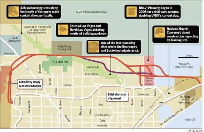
At 438 sites along the wash, bones dating back 200,000 years lie openly on the desert surface.
Protected by the Bureau of Land Management, the area is so valuable that it is accessible only to those with a BLM permit. Even accidental wanderers are strictly forbidden from disturbing any of its rarities.
Now there is great concern over the area’s future, concern greater than at any other time in the four decades-plus since the fossils’ discovery.
Because of expected growth, thousands of new homes and residents will soon enough encroach upon what once was home only to desert tortoises and cactuses. To accommodate that growth, a transportation corridor has long been planned.
Until recently, no one knew exactly where that highway would go. Now people have a rough idea of the proposed Sheep Mountain Parkway’s path. And many don’t like it one bit.
Where it would go
Starting near the northwest limit of Interstate 215, just north of Ann Road, the 22-mile highway would shoot north for about five miles, curve gently to the east and pass U.S. Highway 95. Continuing east, it would skirt the southern end of the Desert National Wildlife Range, passing through an area reserved for a future UNLV campus between Lamb Boulevard and Pecos Road, go through Nellis Air Force Base’s Small Arms Range and connect to I-15 just beyond the Las Vegas Motor Speedway.
Because of the transportation corridor, thousands of acres of once-remote lands will come front and center, causing many area residents to worry about how the desert landscape and the wealth of fossils and rare plant life will be preserved.
Public meetings will be held May 9 and 20 to discuss an environmental impact statement being prepared for the stretch of desert the Sheep Mountain Parkway would traverse.
Another meeting is to be held on a yet-undetermined date in July to give the public another chance to give ideas to highway planners about the proposed route, which would intersect the Upper Las Vegas Wash.
The meetings are sponsored by the Nevada Department of Transportation and the Federal Highway Administration in cooperation with Las Vegas, North Las Vegas and the Regional Transportation Commission.
Las Vegas City Councilman Steve Ross, whose ward covers the area, did not return calls to discuss the proposed highway. Neither did Councilman Larry Brown, whose district would include the area if he wins the Clark County Commission seat he is seeking.
North Las Vegas officials said the city does not have a formal opinion on the major route that would cut through the city’s northern tip. That city is following Las Vegas’ lead, said Qiong Lu, public works director.
Study is under way
One question residents and concerned neighbors have: Why does the city need an environmental impact statement, when an extensive study of the area is being conducted for the BLM by Utah State researchers?
Although many in the conservation and preservation communities believe the new report is a waste of taxpayer dollars, Las Vegas spokeswoman Diana Paul said the two studies are different.
The Utah State study, being conducted by the school’s Environment and Society Department, is examining how different preservation alternatives will affect developable land.
For the study, Utah State’s Glen Busch, project manager, said precise counts and locations of fauna were registered in a database through global positioning system devices. By the end of August the school is expected to complete a draft report, which the BLM then will use as part of an overall environmental impact statement.
Residents are eager to see that study. Emotions are running high, because the city and many residents differ greatly over how much of the so-called Conservation Transfer Area should be preserved. The BLM has the ultimate authority in that decision.
City favors development
Of six possible preservation plans, the city prefers the one that preserves the fewest acres — and, by extension, opens the most acreage to potential development.
Preservationists and a growing number of northwest valley residents are at the other end of the spectrum. In contrast to the city’s desire to save only 2,300 acres, they want to preserve the full 13,000 acres.
They visualize those 13,000 acres becoming something like Red Rock Canyon, a recreation area with nature as center stage. Because of the value of the fossil finds and the rarity of some of the desert flora, including buckwheat and bear poppies, they argue the area could be a huge educational resource and tourism draw.
The city argues for the smaller plot because it wants to maintain a corridor for growth into northwest valley, along U.S. Highway 95. The city, already pinched between the Desert National Wildlife Range to the northeast and the Paiute Reservation to the southwest, wants to keep open a big enough space between those two protected areas for roads and infrastructure into the northwest expanse.
Abdelmoez Abdalla, the Federal Highway Administration’s environmental impact manager in Nevada, said nothing will be decided for some time.
“All we’re saying now, we’re going to study this transportation corridor,” Abdalla said. “And whatever we’re going to choose then has to match what the BLM has, too.”


Join the Discussion:
Check this out for a full explanation of our conversion to the LiveFyre commenting system and instructions on how to sign up for an account.
Full comments policy