
A view of King’s Pool in the Ash Meadows National Wildlife Refuge Tuesday, March 5, 2024.
Monday, March 18, 2024 | 2 a.m.
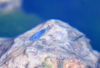
Kevin DesRoberts watches as speckled dace and Amargosa pupfish dart through one of the springs at the Ash Meadows National Wildlife Refuge.
It’s a sight environmentalists are working to save.
“Any changes in the landscape, any alteration of the soil vegetation could wind up changing how water moves across the watershed,” said DesRoberts, a wildlife refuge manager for U.S. Fish and Wildlife Service who is the acting manager of the refuge at Ash Meadows.
One such alteration could come from a lithium mining operation proposed for Ash Meadows, which is located in Amargosa Valley on U.S. Route 95 in Nye County, about 120 miles northwest of Las Vegas.
Rover Critical Minerals, a publicly traded minerals exploration company in Canada, is seeking approval from the Bureau of Land Management to drill 20 bore holes into the groundwater table on public lands just north of the refuge. The company is hoping those holes uncover large deposits of lithium — a key component used in the batteries for electric vehicles.
The proposal is bringing concerns from environmentalists, who say it would destroy the frail ecosystem and endangered or threatened species residing in the area.
“We of course are primarily very deeply concerned about the refuge and impacts to endangered species, but as important if not more so is what this could mean for the long-term water security of the region for the communities,” said Mason Voehl, the executive director of the Amargosa Conservancy.
The BLM temporarily halted exploratory drilling at the refuge in July after the Amargosa Conservancy and the Center for Biological Diversity filed a lawsuit to protect the refuge’s natural springs.
However, Rover Critical Minerals submitted updated plans in December with a smaller reach, going from 30 holes in the initial proposal to 20. It would drill until groundwater is encountered.
“The plan was developed to ensure that there will be no impact to the critical water tables and sensitive biological resources in the Amargosa basin,” said Judson Culter, CEO at Rover Metals, in a statement about the plans.
It’s a plan conservationists continue to passionately oppose.
One of Rover’s proposed drilling sites lies about 500 yards from the source of Fairbanks Spring, the northernmost spring in the refuge. It begins as a 6-foot deep, crystal clear pool of water carpeted in green algae where water bubbles up from the deep carbonate aquifer that supplies the entire refuge, labeled basin 230 by the United States Geological Survey.
The U.S. Fish and Wildlife Service bought land for the refuge from several private landowners starting in 1984. Today, the 24,000-acre network of springs and streams east of Death Valley National Park is considered the second-most biologically diverse area in the United States, full of sensitive and endangered species including the Devils Hole pupfish.
A free-flowing hole like that could deplete the Fairbanks Spring, and since the springs are all connected, it could affect the entire refuge, DesRoberts said.
Those changes could include sedimentation and an influx of invasive species into the refuge. And, he stresses, Ash Meadows wouldn’t be the only ecosystem affected by the project.
Water from Fairbanks Spring, along with Soda Spring, Roger Spring and Longstreet Spring, flows into the Carson Slough, a large spring discharge area that runs south through the refuge into Alpine County, Calif. That water also feeds the partially underground Amargosa Wild and Scenic River.
“All the waters come in this way and work their way down toward Death Valley National Park,” DesRoberts said.
Before the conservancy formed the refuge, the area was mostly divided and developed for agriculture. Fairbanks Spring and others were altered and diverted for crop irrigation. Since then, workers have filled in ditches and rebuilt natural stream paths.
During floods, especially in monsoon season, those springs fill up and connect even more, giving the pupfish a chance to spread out and breed, increasing their numbers. As the water recedes, they’ll return to the springs.
“It’s an incredibly dynamic environment,” DesRoberts said. “There’s so much we don’t know when things like that happen, how it’s affecting all the other species, but it plays a critical role in how the whole ecosystem functions.”
Voehl said the conservancy was hoping for urgent action from the Department of the Interior, but he suspects the back-and-forth between the refuge’s advocates, Rover Critical Minerals and the Bureau of Land Management will take years. He said Rover Critical Minerals must first submit its plans for the National Environmental Policy Act review process.
In the interim, the Nature Conservancy is funding a study of the entire basin analyzing what mining could mean to the public land.
“We hope that’s going to be instrumental in defining an area around the refuge that we would like to see the (Biden) administration remove from new mining claims, hitting a temporary pause button on a defined area in light of what the science justifies,” Voehl said.
It’s a vitally important study, Voehl says, because residents near the refuge have already reported domestic groundwater wells falling.
“This is already such a stressed system,” Voehl said. “Residents near Amargosa Valley are very concerned about the stress a project like this, or others in the watershed, could have on their water supply.”
[email protected] / 702-948-7836 / @musettasun