Jason Bean / The Reno Gazette-Journal via AP, File
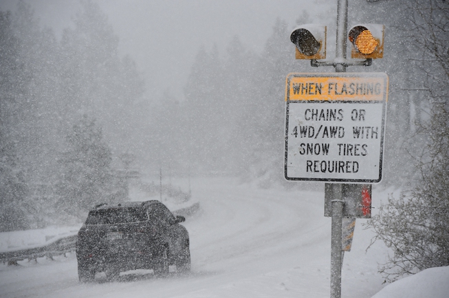
A car passes a caution sign as heavy snow falls on the Mt. Rose Highway near Reno, Nev., on Dec. 1, 2022. The federal government on Friday, April 28, 2023, has made Nevada state, tribal, and local entities eligible for financial assistance for costs of recovering from severe winter storms that affected rural parts of the state in March.
Sunday, Dec. 17, 2023 | 2 a.m.
Scientists rely on an array of multimillion-dollar weather satellites to determine when and where rain turns into snow in the Nevada mountains.
But there’s a fine line between snow and rain at high elevations, one that humans like Paul Eykamp, who lives in the mountains near Lake Tahoe, are better at finding. He jumps into his four-wheel-drive SUV and starts driving up and down the mountain highway to see for himself.
“Since it’s always snowing at our house, being able to predict what it’s going to actually do is very important to us,” said Eykamp, who is part of a network of 1,100 volunteer weather spotters organized by the Desert Research Institute in Las Vegas.
Their job is to help fine-tune the data provided by the satellites, which can struggle to pinpoint the rain-snow transition.
Eykamp said driving up and down Mt. Rose Highway routinely takes him through snow and rain. He reports his observations with an app on his phone.
Sometimes he takes his children along and turns the whole thing into a game, letting them report their findings as he drives.
“It’s fun; it’s a challenge,” he said. “Occasionally, when I know there’s going to be a (rain/snow) transition right below my house, I will say, ‘Hey, we should go to the store right now.’ ”
Since the program launched in 2019, NASA has used the data volunteers collect to check satellites readings for accuracy and adjust. Small inaccuracies mean everyone from avalanche forecasters to water planners could be caught off-guard by weather they weren’t warned about.
Keith Jennings, former hydrologist at the Desert Research Institute, raised the issue of rain-snow transition with DRI Associate Research Scientist Meghan Collins and Dr. Monica Arienzo in 2019, and they began planning for the possibility of a volunteer program.
“Hydrologists have been working on this for a long time,” Collins said. “One of the resources they rely on is NASA satellites. It’s not the only kind of monitoring technology that needs improvement, but it’s the one where we saw a direct line that we could work on together.”
When the program initially started, volunteers focused solely on the Sierra Nevada Mountains region. Collins said after the first two years, they submitted a proposal to a citizen earth science program at NASA to collect data in other regions.
Since then, they’ve expanded to the Pacific Northwest, the Rocky Mountains in Colorado, mountainous regions of Vermont and New Hampshire.
Volunteers sign up for text notifications for their regions and receive weather alerts when there’s a chance of snowstorms or freezing rain.
Then, the Desert Research Institute research team processes the reports and gives NASA a report card detailing how accurate their satellites readings were.
For Clair Julia Sullivan, a retired ski patroller and data scientist, volunteering with the program merged several of her interests seamlessly.
“I’ve done some work in snowfall analysis from satellite imagery and data before, totally unrelated to this, but it’s always been something that’s been of interest to me,” Sullivan said.
“Also, I’m a Ph.D. researcher and so I know the value of having real-time data on the ground.”
She lives five miles south of Breckenridge, Colo., and 1,000 feet higher, near the Continental Divide, which creates interesting weather patterns. If it snows while she’s out hiking, she finds herself sending new reports every few minutes as the weather shifts.
“The weather between my house and Breck can be so incredibly different, and it’s one valley that runs through the whole thing, so the winds do strange things,” Sullivan said.
Eykamp said a single degree colder or warmer in the Sierra Nevada mountains can shift the snow line — the elevation level where snow starts to fall — by thousands of feet. A lower snow line means a longer snowmelt in spring.
“In the mountains, the terrain matters a lot,” he said.
During one storm last year, Eykamp watched the snowline drop from about 9,000 feet to 5,000 feet.
“Forecasters go crazy trying to figure out if the warm air is going to get here faster than the cold air,” Eykamp said.
Collins said the Sierra Nevada mountains get a lot of warm, wet air from the Pacific Ocean that climbs in elevation when it reaches the mountain range. The water condenses and becomes precipitation, going from a warm rainstorm to a cold snowstorm as it climbs. The line between the two is called the rain-snow transition.
The line can shift as temperatures change, causing the kind of rain-on-snow events that lead to sudden and severe flooding. Unexpected freezing rainfall can also make conditions much more dangerous for drivers than unexpected snowfall.
What the volunteers collect isn’t used for forecast or National Weather Service warnings. The data goes to NASA for satellite enhancement.
New volunteers can join by visiting rainorsnow.org or by texting 855-909-0798. Texting the keyword “weather” will send the user general information about the program.
Last year, the program received 23,000 observations from 1,100 observers across the country. Collins, the associate research scientist heading the program, said she wants to log 100,000 volunteer observations by the end of 2025, but that’s not all she’s aiming for.
“There’s not just a goal in terms of numbers, but a kind of qualitative goal for people feeling empowered, that they can make a difference in this hydrologic project,” Collins said.
[email protected] / 702-948-7836 / @Missmusetta
