
Manas Mandal holds an umbrella for his daughter Sohini, a second-grader at Bartlett Elementary School, as they arrive at the school during a rainstorm in Henderson on Tuesday, Sept. 13, 2011. “It is a welcome rain,” Mandal said.
Published Tuesday, Sept. 13, 2011 | 5:17 a.m.
Updated Tuesday, Sept. 13, 2011 | 10:18 a.m.
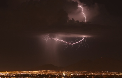
Lightning crackles above the Las Vegas Valley during a storm that passed through which brought about a half-inch of rain to North Las Vegas, knocked out power in some neighborhoods and damaged at least one home and about 20 trees, according to fire and utility officials September 13, 2011.
Sun weather coverage
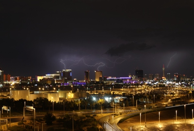
Showers and thunderstorms pounded the Las Vegas Valley this morning, briefly leaving thousands without power and creating headaches for motorists during the morning commute.
Heavy rain began pouring into the Silverado Ranch area and Henderson shortly before 8 a.m., forecasters said. The storms moved into the eastern valley and northeast Las Vegas soon after, while also drenching Boulder City.
A flash flood warning for central Clark County expired at 10:15 a.m. A flash flood watch was posted through midnight tonight for the valley as forecasters said heavy rain could continue to develop over Southern Nevada.
Up to 2 inches of rain could fall today in areas that received heavy downpours this morning, the weather service said.
By 9 a.m., McCarran International Airport had recorded about 0.61 of an inch of rain since midnight, although greater amounts fell elsewhere in the valley. The heaviest rain fell during the 8 a.m. hour, when McCarran recorded 0.32 of an inch.
A trained weather spotter reported more than a foot of water flowing through the intersection of Nellis Boulevard and Stewart Avenue, forecasters said. Shortly after 8 a.m., water was reported flowing across the intersection of Boulder Highway and Russell Road, then spilling into a nearby flood channel.
“If traveling ... Be alert to the possibility of water on the roadway. Never drive your vehicle into areas where water covers the road. Turn around ... Don’t drown!” the weather service said in a flood advisory statement posted this morning.
McCarran spokesman Chris Jones advised travelers to check flight statuses with their airlines before heading to the airport today. Lightning earlier this morning prevented planes from being refueled, causing delays, he said.
Jennifer Schuricht, a spokeswoman for NV Energy, said about 5:40 a.m. that there had been some power outages overnight throughout the Las Vegas Valley and that there were still some areas without power. Schuricht said crews were out working to restore power to about 1,000 customers scattered throughout the Las Vegas area. There was a power outage affecting about 6,000 customers in downtown Las Vegas overnight, but that power was restored in about 90 minutes, she said.
Lightning flashes above the Las Vegas Valley early Tuesday morning during a thunderstorm that brought heavy rains and several reports of lightning strikes. Around 6,000 NV Energy customers lost power for about 90 minutes in downtown Las Vegas during the storm, a utility spokeswoman said.
Tim Szymanski, of Las Vegas Fire & Rescue, said calls started coming in about 2 a.m. through about 4 a.m. regarding damage as a first round of storms moved through.
Szymanski said there were about 20 tree fires and one power pole hit by lightning. At 4:43 a.m., lightning caused about $1,000 in damage to a roof of a home at 2600 Living Rock Ave. However, he said there were no injuries to the two adults and four children who live there and that they were back in their home by 5:44 a.m.
Automated weather stations and radar estimates from that first round of storms indicated between a third of an inch to a half of an inch of rain fell in parts of western North Las Vegas, mainly along and just east of Decatur Boulevard and in the far northwest portions of Las Vegas near Farm Road and the Iron Mountain Club.
Runoff from heavy rain led to ponding of water on roadways. Normally dry washes were expected to have elevated water levels, forecasters said.
Temperatures in the valley will remain relatively cool today, with highs around 81 on the west side of the valley to around 92 degrees on the east side, forecasters said.
The normal high for today's date at McCarran is 95 degrees and the record high was 109 degrees, set in 1948.
Temperatures are expected to drop to 85 degrees by 7 p.m., to 81 degrees by 9 p.m. and to 76 degrees by midnight, forecasters said.
Wednesday's morning low will be 69 degrees and Wednesday's high will climb to 87 degrees, they said.
Join the Discussion:
Check this out for a full explanation of our conversion to the LiveFyre commenting system and instructions on how to sign up for an account.
Full comments policy