National Weather Service
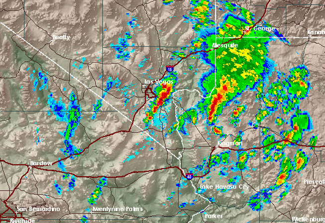
National Weather Service radar shows storms to the south and east of the Las Vegas Valley at about 11:30 a.m. Monday.
Published Monday, Oct. 4, 2010 | 10:50 a.m.
Updated Monday, Oct. 4, 2010 | 8:50 p.m.
Lake Mead Area Flooding
Flooding is shown on this iPhone video Monday taken at Callville Bay in the Lake Mead National Recreation Area. (Video by Todd Austin/National Park Service)
Sun weather coverage
Heavy rain in the Las Vegas area Monday disrupted traffic in the ground and air, flooded rural areas and caused damage to the Lake Mead National Recreation Area.
A severe thunderstorm watch was posted for all of Clark County until it was allowed to expire at 7 p.m.
McCarran International Airport flights traveling north and east out of Las Vegas were delayed up to 90 minutes for much of Monday afternoon and inbound flights not in the air were being told to stay on the ground. Airport spokesman Chris Jones said at about 4 p.m. that all flights were cleared to depart for McCarran.
He said passengers should still expect delays for inbound flights and an hour-long backup for many outgoing flights.
“For anyone flying or picking someone up, the best thing to do is to check your particular flight time online,” Jones said.
Some flights en route to Phoenix were being diverted to Las Vegas because of storms in Arizona.
Up to 30 flights were diverted from Phoenix Sky Harbor International Airport to other cities due to severe thunderstorms Monday afternoon in the Phoenix metropolitan area. Sky Harbor officials say the flights were diverted to airports in Tucson, Flagstaff, Las Vegas, Albuquerque, N.M., El Paso, Texas, and Ontario, Calif.
The effect of the storms also was felt in the Lake Mead National Recreation Area.
Entrances to the Lake Mead area were closed to traffic part of Monday afternoon at Lake Mead Parkway, Lake Mead Boulevard, Overton and Boulder Beach. Much of Northshore Road also was closed so crews could assess storm damage, but it reopened later in the evening.
“Until the water stops flowing we won’t be able to assess the damage,” Lake Mead National Recreation Area spokesman Andrew Munoz said.
Munoz said water reached the road at several points along Northshore Road where the road crosses washes that drain into Lake Mead. Damage was reported at the Callville Bay Marina, but no private property was damaged. Callville Bay Road was reopened Monday evening.
Munoz advised those driving in the Lake Mead area to use extra caution.
“We always recommend no one try to cross the wash when there’s water flowing,” he said.
Access to the Meadview area in Arizona was washed out. Officials said roads in the Lake Mead area could be closed throughout the day.
The Nevada Department of Transportation reported that northbound and southbound lanes of U.S. 95 at Railroad Pass were closed for about 45 minutes due to water on the roadway after nearly an inch of rain fell. The highway reopened about 12:50 p.m.
A flash flood warning was extended several times Monday and continued until 10 p.m. for rural northeast Clark County. A flood warning that included parts of Henderson and the eastern Las Vegas Valley was allowed to expire earlier in the afternoon.
Officials said the areas with the potential for the strongest storms included Moapa, Logandale and Valley of Fire State Park.
Forecasters said 1 foot of water was rushing through an intersection this afternoon in Logandale, in eastern Clark County. More rain continued to fall in that area, which brought the threat of additional flooding.
"Thunderstorms continue to form to the south of the warned area and then move north into and across the warning area. These thunderstorms are moving over the same washes and any new rainfall is being added to the rain and problems which have already been seen during the afternoon," the weather service said in a statement Monday evening.
McCarran International Airport, the official rain gauge for Las Vegas, stayed dry through this evening as most rain fell well east of the airport.
The weather service warned that water levels could rise in normally dry washes in eastern Clark County and into Arizona. A remote area of Mohave County, Ariz., recorded an inch of rain in one hour late Monday morning, the weather service said.
The storms were part of a low pressure system moving into California. Storms will lift into the northern intermountain region Thursday and Friday, allowing for a drying trend, with temperatures returning to near normal for the weekend, forecasters said.
Temperatures will be 15 to 20 degrees below normal Tuesday and Wednesday, the weather service said.
The Associated Press contributed to this report.

Join the Discussion:
Check this out for a full explanation of our conversion to the LiveFyre commenting system and instructions on how to sign up for an account.
Full comments policy