
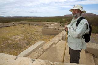
Dean and Edie Hiedeman of Henderson look over the remains of the schoolhouse at the town of St. Thomas in the Lake Mead National Recreation Area Monday, July 22, 2013. The town started as a farming settlement in 1865 but was covered by the rising waters of Lake Mead in the 1930’s after the construction of Hoover Dam.
Sunday, Sept. 15, 2013 | 10 a.m.
St. Thomas
 Follow along as the Sun explores and defines Nevada
Population: Today, zero. At its height, 500 — with up to 1,500 in the area.
Location: About seven miles southeast of Overton. From Las Vegas, about 65 miles northeast via Interstate 15 and the Valley of Fire Highway. It’s in the Lake Mead National Recreation Area, which requires an entry fee.
GPS: 36.466247°, -114.370517°
Elevation: 1,166 feet
St. Thomas is known for one thing: It was the town that was flooded in 1938 by Hoover Dam. The history is much richer than that, and in recent years, people have been able to explore it. Due to the recent drought, the water that once covered the site — about 60 feet deep — is gone, and you can scramble down to the site and wander among the foundations, cisterns and tamarisk.
The story of St. Thomas is, in many ways, the story of Nevada — hearty pioneers came to try to make a living here and when things didn’t work, they moved on. The town was eventually given up for something with better benefits — Hoover Dam.
The town was founded by Mormon pioneers in 1865 and named after one of the expedition’s leaders, Thomas Sassen Smith. The group was sent by Brigham Young to grow cotton and open a supply route to Utah via the Colorado River.
The pioneers suffered several hardships, heat, malaria-infested mosquitoes and scorpions. They dug miles of irrigation canals but found the cotton didn’t grow well. There were also some conflicts with local Indians. But what pushed the Mormon pioneers out was a tax bill presented by Lincoln County officials after an 1870 survey put St. Thomas in Nevada. Residents thought they were in Utah or Arizona. Nevada didn’t relent on the issue, and Young blessed the group’s return. All but one left.
The town was taken over by a variety of settlers, including outlaws and others looking for a remote place to hide out. But Mormons would return to the area and resettle it, trying a variety of crops and taking advantage of its position on the road from Los Angeles to Salt Lake City. It was a stop on what became known as the Arrowhead Trail with a bridge that crossed the Muddy River.
Motorists in the early 1900s could cruise through, finding a broad, leafy boulevard with a hotel, cafe and able mechanics. But the bust of nearby mines in the early 1900s hurt the town economically, and then the bridge was destroyed in a fire in the 1920s. With the plans for Hoover Dam taking shape, a new bridge was built to the north, along with the new highway, away from where Lake Mead would take shape.
Residents fought the federal government to no avail and complained about what they said was the government’s low payments for their properties. Nearly all of the residents left well before the lake flooded the town, but there were a few people who denied that the lake would rise that high.
The last of those was Hugh Lord, who woke to water at the foot of his bed one morning. He gathered his things and before climbing into his rowboat, set fire to his house. Why? The histories don’t say, but it seems like a fitting Nevada way out — one last shake of the fist at the federal government, which might force him out but couldn’t take everything he had.
If you go: St. Thomas is on the edge of the Lake Mead National Recreation Area. An entry fee is required. A dirt road leads from just inside the park gate, southeast of the intersection of Valley of Fire Highway and North Lakeshore Road, and goes about 3.5 miles to a parking area. (Bring water, there are no facilities at the trailhead.) A trail descends from the parking area to the valley floor. It’s a little more than a half-mile to the edge of the town site. The loop trail runs about 2.5 miles.
The St. Thomas Cemetery, which was moved before the lake was flooded, is off Highway 169 just outside of Overton. It is on the west side of the highway, just north of the Simplot facility.
The Lost City Museum, which features artifacts from nearby Anasazi Indian ruins which were flooded by Lake Mead, is north of the cemetery off Highway 169.
Remember: It’s against federal law to use a metal detector or take anything. And park staff frowns on climbing on the foundations. (Sorry.)
For more: “St. Thomas: A History Uncovered,” by Aaron McArthur, will be published in November. It will be the history of the town, and it focuses on the Mormon roots. The book comes out of work McArthur did for the National Park Service, which then led to a Ph.D. dissertation at UNLV. It’s a solid, well-researched and readable history.
Links:
The National Park Service’s site is here.
Join the Discussion:
Check this out for a full explanation of our conversion to the LiveFyre commenting system and instructions on how to sign up for an account.
Full comments policy