
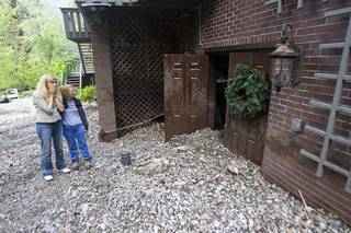
Hannah Weipert watches storm runoff along Kyle Canyon Road near Highway 158 on Mount Charleston Sunday, Sept. 1, 2013. Kyle Canyon Road was temporarily closed at Highway 158 after heavy storm runoff tore through the Rainbow Canyon subdivision.
Wednesday, Sept. 18, 2013 | 2 a.m.
Sun archives
After a month of rains wreaked havoc on homes on Mount Charleston, forest officials say aerial mulch drops on the charred mountainside should help reduce runoff and lessen the severity of flash floods.
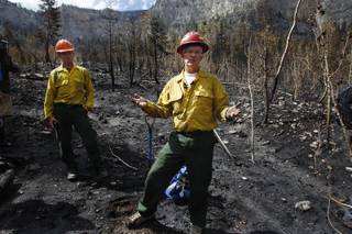
Burn-response crews began surveying the mountain in July, even while the Carpenter 1 Fire still raged on the mountain.
Their work resulted in a nine-point Burned Area Emergency Response plan last month that lays out a series of measures to help protect residents and the forest in the wake of the fire.
Although crews already have begun instituting facets of the plan, one of its biggest components, dropping straw mulch from helicopters across more than 400 burned acres, is scheduled to begin later this week.
The mulching is designed to replace the ground vegetation that was burned up and will serve the same purpose — reducing runoff and protecting seeds already in the soil. The straw will encourage new plant growth.
Officials estimate it will take five days for the helicopters to drop the straw mulch over the targeted area.
The fire, which stretched across 27,881 acres of the mountain, burned so hot the soil in many areas became impermeable to water, leading to accelerated runoff flows in August and September that resulted in heavy flooding around the mountain, especially in the Rainbow Subdivision, where several homes were severely damaged.
Jim Hurja, a soil scientist with the U.S. Forest Service, is coordinating the burn response on Mount Charleston. He said the main goal of the mulching and other measures in coming months is to protect residents, prevent damage to infrastructure and ensure the forest has a chance to recover from the fire.
“The biggest things we have that are at risk are a lot of the infrastructure in Kyle Canyon, so we want to minimize the impact to those. Campgrounds, picnic areas, roads,” he said. “We’re looking at threat to life, threat to property and threat to resources.”
For residents on the mountain, help can’t come soon enough.
Becky Grismanauskas, a town board member whose home of 23 years suffered serious damage in the floods, said she’s glad to see the Forest Service taking quick action, but she and other residents are nervous about what’s next.
“If something isn’t done, we might not need to worry about it in the spring,” she said, talking about the chance for increased avalanches during the winter and more flooding during the spring thaw. “Because if we get a serious runoff from the snow coming off the mountain, none of us are going to be here.”
Grismanauskas complimented representatives from the Forest Service and local governments for building a strong relationship with residents and keeping them updated through a series of community meetings.
“At least they’re not just sitting there and waiting until next spring. They’re taking action. I don’t know how anybody can be grumpy with that,” she said.
Clark County Commissioner Larry Brown, who represents the area, said restoring Mount Charleston and protecting residents after the fire would be an ongoing process that takes years.
“We can never go fast enough, but we’re in it for the long haul. It’s going to be a generation before the mountain heals,” he said. “These professionals and residents working together have to mitigate the things that are going to happen over the next few years. I’m very pleased with the commitment everyone has put toward the aftermath.”
The steps laid out in the Burned Area Emergency Response plan were drawn from a catalog of previous treatments that have proven to be successful, Hurja said.
Contractors will perform much of the work, including the helicopter mulching. Total cost of the measures is expected to be $1.5 million, he said, which will be paid for using federal emergency funds.
In addition to mulching, crews will be closely monitoring the area to identify and stop the spread of invasive weeds. Other work is being done to clean out and improve drainage structures along several roads and trails.
Certain areas of the mountain, including the South Loop trail and Griffith trail, will remain closed at least through the winter, Hurja said. The burn-response funding includes money to install signage alerting visitors of the closed areas.
Perhaps the biggest undertaking will be an Army Corps of Engineers project designed to divert water away from sensitive areas of the mountain. Hurja said those discussions and where the funding would come from are still in preliminary stages and no firm solutions have been put forward.
Join the Discussion:
Check this out for a full explanation of our conversion to the LiveFyre commenting system and instructions on how to sign up for an account.
Full comments policy