
National Security Archive / www.nsarchive.org
A newly-declassified CIA map showing Area 51 released by the National Security Archive.
Published Thursday, Aug. 15, 2013 | 1:50 p.m.
Updated Thursday, Aug. 15, 2013 | 2:51 p.m.
Map of Area 51
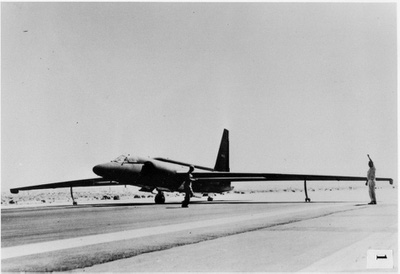
This photo shows a U-2 on a landing strip was part of a CIA report on U-2s that includes information on Area 51 and was recently declassified.
WASHINGTON — The government has finally recognized the existence of Area 51, according to the National Security Archive, which published recently obtained declassified CIA reports detailing and mapping the previously unacknowledged area in Nevada.
The National Security Archive at George Washington University published a report, "The Secret History of the U-2," on the spy planes that the Central Intelligence Agency relied on during the Cold War.
The Archive obtained declassified documents about the history of the U-2 — which reference Area 51 on numerous occasions — through a Freedom of Information Act request filed in 2005.
The origins of Area 51 are tightly bound up in the history of the U-2, for which the CIA needed a reliable and secret test facility in the U.S.
They found it in Groom Lake on April 12, 1955, according to “The Central Intelligence Agency and Overhead Reconnaissance,” an internal CIA history of the U-2 and OXCART programs written by Gregory W. Pedlow and Donald E. Welzenbach that was declassified in fulfillment of the National Security Archive’s FOIA request.
OXCART was the code name for the program to develop the Lockheed A-12 reconnaissance plane.
“On 12 April 1955, Richard Bissell and Col. Osmund Ritland (the senior Air Force officer on the project staff) flew over Nevada with Kelly Johnson on a small Beechcraft plane piloted by Lockheed’s chief test pilot, Tony LeVier,” an excerpt from the history reads. “They spotted what appeared to be an airstrip by a salt flat known as Groom Lake, near the northeast corner of the Atomic Energy Commission’s (AEC) Nevada Proving Ground.”
LeVier landed their plane on the lake bed so the group could inspect the area more closely. They agreed Groom Lake would be an ideal site and asked the AEC to add it to its real estate holdings in Nevada.
“President Eisenhower also approved the addition of this strip of wasteland, known by its map designation as Area 51, to the Nevada Test Site,” the history continues. “The outlines of Area 51 are shown on current unclassified maps as a small rectangular area adjoining the northeast corner of the much larger Nevada Test Site. To make the new facility in the middle of nowhere sound more attractive to his workers, Kelly Johnson called it the Paradise Ranch, which was soon shortened to the Ranch.”
Not all of these details have been secret for the last 58 years. But the declassification opens up a world of possibilities for what else the public may now be able to learn about Area 51.
“It marks an end of official secrecy about the facts of Area 51,” said Jeffrey Richelson, a senior fellow with the National Security Archive who found the documents. “It opens up the possibility that future accounts of this and other aerial projects will be less redacted, more fully explained in terms of their presence in Area 51.”
The history notes that the first planes were delivered to Area 51 on July 25, 1955, and the first taxi trials began two days later. The first test flight took place Aug. 4, 1955.
Military Air Transport Service flights, which brought Area 51 employees in from Burbank, Calif., on Monday mornings and returned them on Friday evenings, began on Oct. 3, 1955.
In 1957, the CIA left Area 51, and the Air Force moved in, using it as a training ground for pilots flying the 29 U-2s that belonged to the Air Force.
Join the Discussion:
Check this out for a full explanation of our conversion to the LiveFyre commenting system and instructions on how to sign up for an account.
Full comments policy