
Remo Wuerth, left, and Sibylle Heinemann, tourists from Switzerland, chat in the rain after taking a bus to the “Welcome to Fabulous Las Vegas” sign Thursday, Jan. 21, 2010.
Published Thursday, Jan. 21, 2010 | 6:03 a.m.
Updated Thursday, Jan. 21, 2010 | 4:38 p.m.
Sun weather coverage
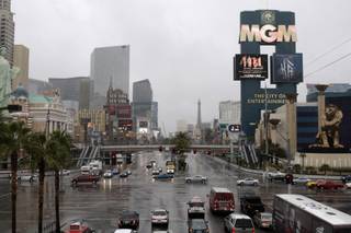
A steady downpour that already has drenched the Las Vegas Valley with more than three-fourths of an inch of rain today disrupted flights at McCarran International Airport and led the National Weather Service to issue a flash flood watch for the valley and southern Clark County through late tonight.
A large number of flights landing in Las Vegas or traveling to California and Arizona have been delayed because of today's storms, McCarran spokesman Chris Jones said.
Jones said different weather conditions across the country have also posed problems for airlines. Travelers should check the airport’s Web site to see if their flight has been postponed, he said.
Because of the heavy rains, several area roads have been closed, local officials announced: Winnick Avenue west of Audrie Street near the Las Vegas Strip, the Rainbow Boulevard and Farm Road intersection and Ranch Road in Moapa, west of State Rout 168.
At 1:39 p.m., local storm spotters reported that rain had changed to snow on the west side of the valley, with a half-inch of accumulation reported in the Summerlin area. Rain mixed with snow is expected to continue over the western valley through mid-afternoon before changing back to all rain by late afternoon, forecasters said.
Meanwhile, the storm passing through the area today has brought heavy snow to area mountains, leading to winter storm warnings there.
The series of storms this week had left 1.61 inches of rain in Las Vegas as of 4 p.m. today. McCarran's total rainfall for all of 2009 was 1.59 inches.
At 1:25 p.m., the weather service issued a flash flood watch for the area, saying periods of heavy rain and isolated thunderstorms will continue for the rest of the afternoon and into the evening hours across Southern Nevada. Some areas will get 1.5 to 2 more inches of rain by the time the storm is finished, forecasters said.
A flood advisory will continue in the valley through 9:15 p.m., with the heaviest amounts of rain coming between 4 p.m. and 9 p.m., forecasters said. The weather service said motorists should watch for minor flooding of roadways, rapidly running washes and reduced visibilities. Forecasters urged motorists not to drive their vehicles into areas where the water depth might be too great to allow their car to pass safely.
A winter storm warning remains in effect until 4 a.m. Friday for Red Rock Canyon, the Spring Mountains and the Sheep Range, which includes the Mount Charleston area, the weather service said.
Snow levels will generally be above 5,000 fett, but local areas will see snow down to elevations of 3,500 feet this evening through Friday morning, forecasters said.
Total snow accumulations of 1 to 2 feet are expected above 7,000 feet by early Friday morning, with 6 to 12 inches above 5,000 feet, forecasters said.
South winds of 15 to 20 mph, with gusts around 30 mph are expected much of the time, making travel difficult or nearly impossible because of blowing and drifting of snow and near whiteout conditions at times, forecasters said.
The weather service says travel in the mountains will become difficult or nearly impossible and motorists who do try to travel should keep an extra flashlight, food and water in their vehicle in case of an emergency.
A flood watch is in effect from 10 a.m. today to Friday morning for portions of northwest Arizona and Southern Nevada, including northeast Clark County. Forecasters said from 1 to 3 inches of rain could cause significant rises in rivers and normally dry washes, wash out dirt and gravel on secondary roads or result in flooded roads.
More rain is expected in the valley Friday and Saturday, then generally drier weather is expected Sunday and Monday, forecasters said.
Rainfall amounts from Wednesday night's storm around the Las Vegas Valley included .27 of an inch at McCarran International Airport, .38 of an inch at North Las Vegas Airport, .12 of an inch at Henderson Executive Airport and .31 of an inch at Nellis Air Force Base.
At 1:56 p.m., the temperature at McCarran was 42 degrees, which was the low for today. The normal low at McCarran for today's date is 37 degrees and the record low was 13 degrees, set in 1937. The normal high at McCarran for today's date is 57 degrees and the record high is 70 degrees, set in 2009.
Temperatures were to drop tonight to 47 degrees by 6 p.m., to 46 degrees by 9 p.m. and to 45 degrees by midnight, forecasters said.
Friday's morning low will be about 42 degrees and Friday's high will be 55, forecasters said.
— Sun reporter Tiffany Gibson contributed to this story.
Join the Discussion:
Check this out for a full explanation of our conversion to the LiveFyre commenting system and instructions on how to sign up for an account.
Full comments policy