
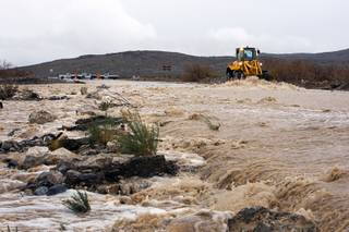
A Nevada Department of Transportation front loader keeps debris from building up as rain run-off washes over the roadway Wednesday on State Route 159 near Calico Basin in the Red Rock Canyon area west of Las Vegas.
Published Wednesday, Dec. 22, 2010 | 6:50 a.m.
Updated Wednesday, Dec. 22, 2010 | 7 p.m.
Rain continues to deluge valley
Rain continues to deluge valley.
KSNV's coverage of the 2010 rainstorms
KSNV covers the area storms on the 4 p.m. and 5 p.m. news broadcasts.
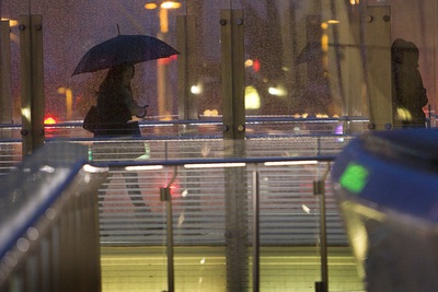
A woman uses a pedestrian walkway at CityCenter on the Las Vegas Strip in the late afternoon Wednesday, Dec. 22, 2010.
Sun Coverage
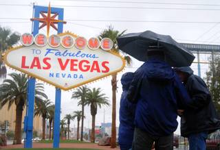
- Las Vegas tourists soaking up wet weather in stride (12-22-2010)
- Officials: 5 vacant homes gone in Arizona flooding (12-22-2010)
- Wet weather damages Magical Forest at Opportunity Village (12-22-2010)
- Rain will lift Lake Mead water levels, but only slightly (12-22-2010)
Sun weather coverage
The storms pummeling the Las Vegas Valley have prompted Clark County officials to issue an avalanche advisory for Kyle Canyon due to snow building up in the area.
Those in the area should evacuate, county officials said. People are being urged not to visit the area due to the avalanche threat and power outages on the mountain.
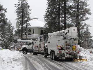
Although most of the valley is seeing rain and not snow, the weather is causing problems throughout Southern Nevada. Continuing storms have closed roads throughout the Las Vegas Valley and prompted a second day of closures at the Red Rock Canyon National Conservation Area. NV Energy has said it could take up to 72 hours to restore service in the Mount Charleston area, which lost power on Tuesday.
The Las Vegas Ski & Snowboard Resort on Mount Charleston has received about 40 inches of snow during the past three days, said Katie Rose, a resort employee.
So far this year, the resort has gotten 90 inches of snow, allowing for a base of 83 inches of snow, Rose said. The resort was closed until about 1:30 p.m. Wednesday because the chairlift could not operate under such heavy snow, she said.
“It’s been pouring” snow all day, Rose said. “We have 98 percent humidity, which is pretty ridiculous.”
She said the resort expected a foot of fresh snow by the end of the day.
The county offered several tips from the National Snow and Ice Data Center in the event of being caught in an avalanche. Punch the snow in front of your face to try to make an air pocket — most avalanche-related deaths are caused by suffocation, officials said.
Once covered in snow, take a deep breath because the snow will quickly begin to harden around you, officials said. Don’t yell until you know people are near, officials said, because it will take up air.
The Nevada Division of State Parks has closed four Southern Nevada parks due to flooding and heavy rainfall.
Valley of Fire State Park near Overton, Spring Mountain Ranch State Park in Blue Diamond, Spring Valley State Park, and Echo Canyon State Park, both near Pioche, in eastern Nevada, are all closed. Officials are unsure when the parks will reopen, said Bob Conrad, spokesman for Nevada Department of Conservation and Natural Resources.
“They’re mainly closed because of roads flooding, not because of the parks flooding," Conrad said.
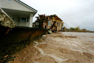
In northeastern Clark County, heavy rains caused minor damage of several homes along the Virgin River in Mesquite.
A flash flood warning has been extended for north-central Clark County, with water up to 3 feet deep running Wednesday morning across Warm Springs Road along the Pahranagat Wash in the northern valley, near Moapa.
The National Weather Service reported flash flooding east of the Hoover Dam on U.S. Highway 93 — an area where heavy rain was expected through much of the afternoon. Nevada Highway Patrol Trooper Chelita Rojas said there was no similar damage on the Nevada side of the dam.
A flash flood watch has been in effect for Southern Nevada. Flash floods had been occurring sporadically throughout the region on Wednesday. Although the heavy rains have moved east of the area, weather officials said the runoff from previous rain would likely continue to cause flash flood problems.
Wednesday afternoon’s flash flood warning has been extended to 9:30 p.m. for central Clark County. The weather service is predicting about .5 inches of rainfall between 3 p.m. and 4 p.m., which will likely cause flooding because the ground is already saturated.
“This event is very anomalous just from the high moisture content that was coming in off the Pacific that brought copious amounts of rain to the valley,” said Barry Pierce, a meteorologist with the National Weather Service. “Typically we don’t see things quite this extreme.”
Pierce said this storm has about twice as much moisture in it as typical winter storms in Las Vegas. Much of that moisture, he said, is coming from as far away as the tropics and Hawaii.
Clark County officials say they're bracing for up to 2 inches of rain, but hope stormy weather will ease overnight.
Stephanie Street at Munson Channel was closed to traffic starting at 7 a.m. Wednesday morning, county officials said. Additional road closures were announced at Farm Road and Rainbow Boulevard, and on Twain Avenue between Industrial Road and Rio Drive, near the Las Vegas Strip.
Valley of Fire Road, east of Interstate 15, was closed at 11:30 a.m. By about 3:30 p.m., Grand Teton and Buffalo Road, and Farm Road and Rainbow Boulevard, were open with lane restrictions. Moonlight at Keith Ann and Grand Teton at Buffalo had reopened, but lane restrictions continue at Grand Teton at Buffalo due to heavy debris and high water.
Arroyo Road in Blue Diamond has been closed since Monday afternoon. Elbow Canyon Road, in Bunkerville, and Ranch Road, Highway 168 to Greasewood, both closed Tuesday, according to Clark County officials.
The weather service called the warning because between .24 and .50 inches of rain was falling per hour, which could lead to flash floods in washes, forecasters said.
Local law enforcement officials have reported that some roads have been flooded in the northwest part of Las Vegas.
The weather service warned motorists that “it only takes 18 inches of swiftly moving water to sweep a vehicle off the road, and less than six inches of swiftly moving water to sweep a person of their feet.” If water covers the roadway, forecasters said, don’t drive on it.
The Red Rock Canyon scenic drive and visitor center on State Route 159 was closed all day due to flooding and debris, BLM officials said Wednesday morning. The area also was shut down on Tuesday due to weather.
North Las Vegas streets had reopened by about 3 p.m. Earlier in the day, numerous streets in North Las Vegas were closed due to flooding, some with as much as one foot of water. Elsewhere, manhole covers had slid off, leading to gushing water at some intersections.
City officials urged the public to be cautious when traveling through water-logged areas, especially those with deep standing or pooling water.
Streets in Henderson were mostly clear Wednesday.
“We’ve put a lot of improvements into our flood channels over the past few years, but as far as today, there haven’t been any problems,” said Henderson spokeswoman Kathleen Richards. No road closures have been announced in Henderson, she said.
Early this morning, flooding was reported in the Pahrump area. The National Weather Service Doppler radar indicated that locally heavy rain would continue over that area, which would also add to the flooding.
Areas affected included Pahrump, the Desert Retreat RV Resort and State Route 160 on the west side of the Spring Mountains.
Power still out on Mount Charleston
About 300 NV Energy customers on Mount Charleston were still without power Wednesday morning, with crews likely spending the next four days putting up power lines to restore electricity.
NV Energy spokesman Mark Severts said crews are being pulled from the Kyle Canyon area of Mount Charleston due to the continuing snowstorm and avalanche advisory.
“Limited progress has been made today,” Severts said. “It’s the same situation as last night. The situation will be assessed first thing in the morning with the Clark County emergency response personnel and with the US Forest Service.”
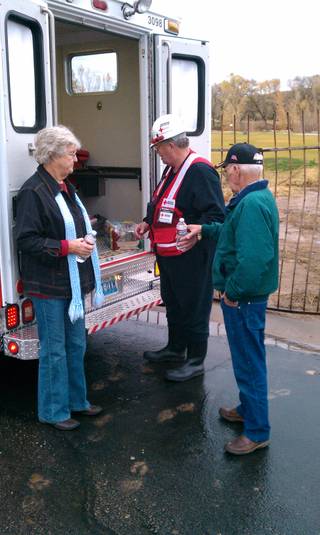
The Red Cross announced Wednesday it would be opening an emergency shelter at 4 p.m. at James H. Bilbray Elementary School, 9370 Brent Lane, to accommodate residents without power. Volunteers were to provide cots and hot meals.
NV Energy said it could take days to fully repair the lines on Mount Charleston. At minimum, it will take crews an additional 72 hours to get main lines back up, said NV Energy spokesman Mark Severts.
“Even after that, you may have some residents without power to individual homes,” he said, saying lines going into residences have likely also been damaged by the storm.
“In terms of a Mount Charleston outage, this is the worst our crews have in memory,” Severts said. “This is the worst in history from the perspective of NV Energy and Nevada Power.”
The biggest cause of the outages is downed power lines, Severts said. Most of the power lines have fallen due to falling tress and branches, and because snow and ice built up on them, causing wires snapped under the weight, he said.
NV Energy crews did not work through the night because of safety concerns, Severts said.
“With it continuing to snow heavily, they’re making no progress yet,” he said, adding that a significant amount of additional damage had occurred overnight.
At 3 p.m., the first NV Energy crews were expected to return from the mountain with status updates, Severts said.
Flash flood watch
A flash flood watch continues through this evening for portions of northwest Arizona, California and southern Nevada, including the Las Vegas Valley.
Forecasters say occasional rain will continue through the day, with isolated thunderstorms producing locally heavy rainfall. Rainfall rates could be between one and two inches an hour, they said.
The rain will cause ponding of water in low-lying areas, as well as rapidly flowing water in normally dry washes, they said. Flows of water and mud or debris might occur over area roads, they said. Travelers, campers and residents should be aware of the potential for flash flooding, forescasters said.
Flooding in Mesquite
Mesquite
Sam Morris discusses Mesquite flooding
Las Vegas Sun photographer Sam Morris talks with KSNV anchor Jim Snyder about flooding in Mesquite.
City officials in Mesquite along the Nevada-Utah border were preparing for more possible flooding along the Virgin River.
Meteorologist Pierce said the Virgin River, which caused flooding in Mesquite, crested above 16 feet Tuesday night. It will likely crest — meaning reach its highest level before flooding over — again Thursday morning at 14 feet, he said.
Officials there said water levels dropped overnight after two homes were slightly damaged Tuesday.
Len DeJoria, a fire prevention officer for Mesquite, has been working with emergency crews. About 30 homes in Mesquite were evacuated voluntarily Tuesday night. Only one of those homes sustained significant damage, DeJoria said.
There has been localized pooling and flooding of water throughout the city, DeJoria said, but most streets are open and residents have been released to return home.
“It has slowed down somewhat for now,” DeJoria said of the weather.
There is a flood warning in effect through Thursday evening for the Virgin River and Beaver Dam Wash in northeastern Clark and north central Mohave counties, the weather service said. County officials were closely monitoring levels in the Virgin and Muddy rivers.
Mesquite Police had asked residents to voluntarily evacuate an area east of Sage Way between East Mesquite Boulevard and East Old Mill Road, forecasters said. An evacuation center was set up at the Virgin Valley High School. Sandbags were made available at Hunter Park.
Mandatory evacuations did occur at Beaver Dam Arizona on Tuesday. Beaver Dam Wash crested at 14.7 feet at 9 a.m. Tuesday.
Temperatures to stay in the 50s
At 5:56 a.m. today, the temperature at McCarran International Airport was 51 degrees. The normal low for today's date is 36 degrees. The record low was 12 degrees, set in 1990.
Around the valley just before 6 a.m., temperatures were 50 degrees at North Las Vegas Airport, 52 degrees at Nellis Air Force Base and 50 degrees at Henderson Executive Airport.
Temperatures in the valley were to rise today to 53 degrees by 9 a.m., to 55 degrees by noon, which is expected to be the high for the day, forecasters said. The normal high for today's date is 56 degrees and the record high was 68 degrees, set in 1950.
Temperatures are expected to drop to 48 degrees by 6 p.m., and remain at 48 degrees at 9 p.m. and at midnight, forecasters said.
Thursday's morning low will be 45 degrees and Thursday's high will climb to 57 degrees, they said.
Join the Discussion:
Check this out for a full explanation of our conversion to the LiveFyre commenting system and instructions on how to sign up for an account.
Full comments policy