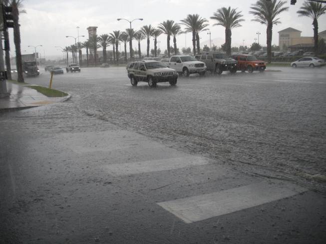
Just outside The District in Henderson, cars on Green Valley Parkway trudge through minor flooding during storms Monday afternoon.
Monday, July 14, 2008 | 6:51 p.m.
(First posted at 9:04 a.m.) The Las Vegas Valley was treated to a weather extravaganza this afternoon, featuring a cast of characters that rarely perform in the desert except in monsoon season — hail, heavy downpours and even street flooding.
Sun Archives
- Storms bringing chance of flooding (7-13-2008)
- Valley gets first soaking since May (7-12-2008)
- Las Vegas escapes thunderstorms - so far (7-11-2008)
- Top 10 tips for flash floods(7-11-2008)
Beyond the Sun
The curtain went up shortly after 1 p.m., when thunderstorms rumbled into the Henderson area, bringing crackling thunder, lightning and strong winds.
Pea-sized hail and pelting rains led to poor visibility on Interstate 215, slowing traffic traveling between McCarran International Airport and Green Valley Drive, according to Sun employees who were traveling along the highway about 1:40 p.m.
Other Sun employees who were out in the soup reported flooding along Green Valley Drive near The District, where cars were splashing through several inches of water. Police scanner traffic also indicated there was street flooding along Horizon Ridge Parkway.
During the brunt of the storm, the National Weather Service issued flash flood advisories and warnings.
The weather service told drivers to be wary of minor flooding in urban areas of Clark County, including Henderson and Green Valley through 3:15 p.m.
At 1:49 p.m., the weather service's Doppler radar and weather spotters indicated that up to a half an inch of rain had fallen since 1 p.m. in the Las Vegas Valley, with more on the way.
Rural areas were also warned about flash flooding in areas frequented by campers and hikers.
Flash flood warnings went out for the Red Rock Canyon National Conservation Area, which had a total of 0.39 of an inch of rain as of 1:55 p.m., according to the Clark County Regional Flood Control District's gauge.
At 2:11 p.m., the weather service's Doppler radar and automated rain gauges indicated two-thirds of an inch of rain had fallen near the Red Rock Canyon Visitors Center.
The weather service issued flood warnings for areas at Red Rock Canyon, Mountain Springs Summit, Calico Basin and the Spring Mountains.
The McCullough Mountains south of Henderson received 0.28 of an inch before 2 p.m. today, according to the Clark County Regional Flood Control District.
A flash flood warning also went up for north central Clark County, which included Hayford Park, Mormon Well Road and Alamo Road, which received between 2 and 3 inches of rain by 2 p.m., according to Doppler radar readings.
By about 3:30 p.m., the curtain fell on most of the desert weather show and all the flash flood advisories and warnings had expired by 4:30 p.m.
Officially, the big storm won't show up in the official readings for the Valley.
That's because McCarran International Airport, which is the official record-keeper for the National Weather Service for Las Vegas, showed only a trace of rain.
McCarran recorded a high today of 97 degrees, with wind gusts during the afternoon between 20 and 22 mph.
Tonight, the chance for precipitation drops to 20 percent, with most of the storm clouds clearing out by 11 p.m. Skies will be partly cloudy, with a low falling to 80 overnight.
Over the weekend, McCarran International Airport reported .04 of an inch of rain, most of which fell late Friday night and early Saturday morning.
The airport also reported traces of rain Saturday morning and Sunday afternoon from storms that passed through the valley.
However, the skies erupted with much more rain Sunday afternoon in some areas of the valley, including Henderson.
On Sunday afternoon, the weather service said that automated Clark County rain gauges reported nearly a half an inch of rain over Henderson. Automated gauges along the Flamingo Wash between Torrey Pines and Decatur measured nearly 0.6 of an inch in less than an hour.
There was also a report of water running nearly a foot deep on the sides of the road near the intersection of Lake Mead Parkway and Water Street in Henderson.
(Sun reporter Mary Manning contributed to this report.)


Join the Discussion:
Check this out for a full explanation of our conversion to the LiveFyre commenting system and instructions on how to sign up for an account.
Full comments policy